Trusted by leading organizations worldwide


Leverage the power of computer vision to monitor shoreline change, track beach visitation, identify coastal hazards and more.
Continuously monitor shoreline position and beach width changes over time.
Detailed, high-frequency beach attendance counts on the beach and in the water.
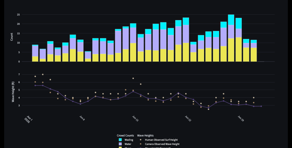
Detailed tracking of waves and surfers, including wave heights, number of surfers, ride lengths, and much more.
Track and measure wave overtopping of dunes, seawalls, and other coastal structures.
Trusted by leading organizations worldwide
Unlocking deeper insights into coastal erosion, bathymetry, and wave dynamics for smarter resilience planning.
Our continuous stream of shoreline data gives stakeholders an in-depth view of how coastlines evolve, how metocean conditions affect the shoreline, and how these changes impact coastal attendance.
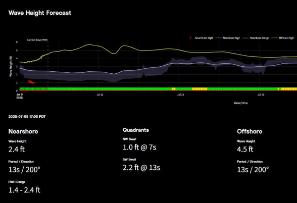
Capture every wave with precision using our surf and wave monitoring technology. Our system analyzes wave height, direction, quality, and detailed surfer activity to deliver valuable data for pre- and post-construction surf monitoring, wave research, surf-amenity studies, and beyond.
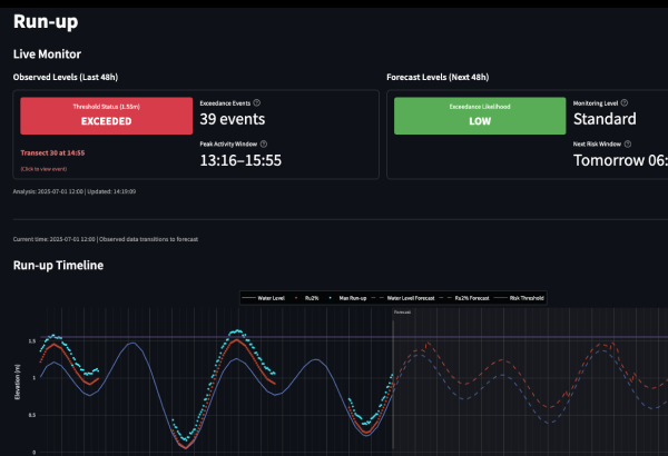
Detect wave run-up and coastal flooding events with clear, near-real-time visuals to help stakeholders understand flooding risks, take early action, and protect vulnerable infrastructure and coastal communities.
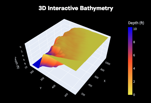
Use advanced video analytics to track how nearshore bathymetry shifts over time, giving coastal managers better data for more accurate modeling, smarter planning, and stronger shoreline resilience.
Reliable attendance data to help communities optimize safety and economic impact.
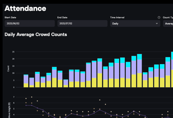
Visualize daily, seasonal, and long-term beach attendance patterns to support smarter coastal planning, optimize resource allocation, and provide valuable insights for tourism and economic analysis.
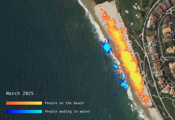
View near-real-time and historical heatmaps to understand where beachgoers gather, surf, or swim — helping manage safety, optimize lifeguard placement, and support coastal operations.
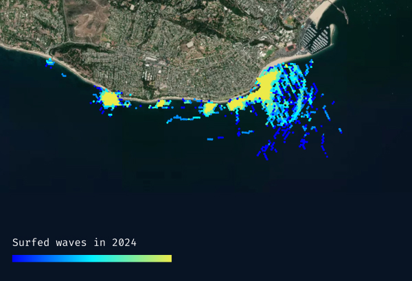
Monitor individual surfers' movement, wave count, and session details to reveal crowd behavior, improve surf forecasting, and inform smarter coastal planning and surf zone management.
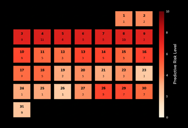
Forecast future beach crowds to help manage resources, safety, and the visitor experience.
Unlocking deeper insights into coastal erosion, bathymetry, and wave dynamics for smarter resilience planning.
Our continuous stream of shoreline data gives stakeholders an in-depth view of how coastlines evolve, how metocean conditions affect the shoreline, and how these changes impact coastal attendance.
Reliable attendance data to help communities optimize safety and economic impact.
Visualize daily, seasonal, and long-term beach attendance patterns to support smarter coastal planning, optimize resource allocation, and provide valuable insights for tourism and economic analysis.
Trusted by coastal engineers, municipalities, academics, lifeguards, and more.
City councils and municipal agencies monitoring coastal infrastructure, public safety, and environmental compliance.
Coastal engineers and consultants designing resilient infrastructure and studying shoreline dynamics.
Beach safety organizations optimizing patrol coverage and emergency response protocols.
Academic institutions and environmental scientists studying coastal processes and climate adaptation.
Surfline Coastal Intelligence delivers live and historical video, continuous coastal monitoring, and predictive modeling in a single, turnkey system.
Complete video monitoring solutions with live streaming and extensive historical archives.
Real-time coastal monitoring with advanced detection capabilities.
Custom forecasting models for proactive coastal management.
Ready to transform your coastal monitoring capabilities?
Book a DemoFrom remote camera installs to high-frequency data collection, Surfline Coastal Intelligence delivers a fully managed, scalable solution trusted by leading coastal agencies worldwide.
Access our existing network or let us install cameras for you anywhere — even off-grid. We handle installation, maintenance and repairs.
Backed by 40+ years of coastal observation and a global team of engineers, our system is trusted at over 250 locations worldwide.
Our cameras connect seamlessly to our cloud servers and deliver processed data via Dashboard or API in near-real-time.
Capture continuous video and 1Hz data across key coastal metrics — including attendance, shoreline change, wave conditions, and more.
No upfront hardware or install fees. Just pay a monthly fee per camera location — simple, scalable, and built to grow with your needs.
Powered by patented methods and a proprietary coastal training dataset, Surfline Coastal Intelligence delivers best-in-class ocean detection.
Join leading coastal organizations who trust Surfline Coastal Intelligence for their monitoring needs.